info
gnss protocol - Network-dat/location-dat/GNSS-dat/quectel_l76-lbl26-lblc86l_gnss_protocol_specification_v2-2.pdf
GSV - GNSS Satellites in View.
GSA - GNSS DOP and Active Satellites. GNSS receiver operating mode, satellites used in the navigation solution reported by the GGA sentence, and DOP values.
GLL - Geographic Position – Latitude/Longitude.
GGA - Global Positioning System Fix Data. Time, position, and fix-related data for a GNSS receiver.
VTG - Course Over Ground & Ground Speed.
RMC - Recommended Minimum Specific GNSS Data. Time, date, position, course, and speed data provided by a GNSS receiver.
tech
What is a POT GNSS Module?
A POT GNSS module refers to a GNSS (Global Navigation Satellite System) module that uses a Patch On Top (POT) antenna design.
- POT stands for Patch On Top.
- The module integrates a ceramic patch antenna directly on top of the GNSS receiver.
- This design makes the module compact, easy to integrate, and suitable for space-constrained applications.
- POT GNSS modules are commonly used for GPS, GLONASS, Galileo, and BeiDou navigation systems.
Summary:
A POT GNSS module is a navigation module with a built-in patch antenna mounted on top, providing a simple and compact solution for satellite positioning.
GNSS Start
COLD start GNSS:
- When first used;
- Loss of ephemeris information due to battery depletion;
- Move the receiver more than 200 km under shutdown.
HOT start GNSS:
- Boot less than two hours from the last location
WARM start GNSS:
- Boot more than two hours from the last location
GNSS bands
| Type | Frequecy |
|---|---|
| GPS | 1575.42±1.023MHz |
| GLONASS | 1597.5~1605.8MHz |
| BeiDou | 1561.098±2.046MHz |
GNSS Antenna Requirements
| Antenna Specification | Specification Requirement |
|---|---|
| Operating Frequency Band | L1: 1559~1609MHz |
| Directionality | Hemisphere, face to sky |
| Impedance | 50 Ω |
| Maximum Input Power | 50W |
| VSWR | < 2 |
| Polarization Type | RHCP or Linear |
| Passive Antenna Gain | 0dBi |
| Active Antenna Gain | -2dBi |
| Active Antenna Noise Figure | < 1.5 |
| Built-in Antenna LNA Gain | 20dB(Typ.) |
| Total Antenna Gain | < 18 dB |
| Coaxial Cable Insertion Loss | <1.5dB |
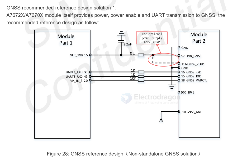
Schematic
board
chip
commands examples
Search GPS + GLONASS:
$PMTK353,1,1,0,0,0*2B

Enable GPS, Glonass, Galileo:
$PMTK353,1,1,1,0,0*2A
Sets the speed threshold for static navigation.
$PMTK386,0.4*39
$PMTK001,386,3*3D
Gets whether the GPS/GLONASS/BDS/Galileo satellite seraching is enabled or not.
$PMTK355*31
$PMTK001,355,3,1,1,0,0*33
PMTK838 PMTK_TEST_ANTI_SPOOFING - Enables or disables jamming detection function.
$PMTK838,1*2C
$PMTK001,838,3,1*2E
PMTK605 PMTK_Q_RELEASE - Queries the firmware release information. See PMTK_DT_RELEASE for the query result.
$PMTK605*31
$PMTK705,MT3333_AXN5.1.9_MODULE_STD_F1_P1,0007,Quectel-L76L,1.0*08
$PMTK705,AXN_5.1.6_3333_19010218,0007,Quectel-L76L,1.0*53
GNSS Log
$GBGSV,2,1,06,03,65,189,40,07,41,202,27,16,27,165,34,27,79,266,39,0*75
$GBGSV,2,2,06,28,46,154,39,32,50,281,47,0*7F
$GNRMC,081456.00,A,2234.27498,N,11353.24761,E,0.000,,010625,,,A,V*1E
$GNGGA,081456.00,2234.27498,N,11353.24761,E,1,13,1.36,28.7,M,,M,,*6D
$GNGSA,A,3,05,11,15,29,18,24,13,,,,,,2.04,1.36,1.53,1*03
$GNGSA,A,3,27,28,32,03,07,16,,,,,,,2.04,1.36,1.53,4*0C
$GPGSV,3,1,09,05,44,017,30,15,66,258,46,18,13,320,31,29,47,278,44,0*6A
$GPGSV,3,2,09,11,32,114,29,13,68,041,26,24,19,179,26,194,,,27,0*62
$GPGSV,3,3,09,199,,,26,0*59
GNSS Data Summary (June 1, 2025, 08:14:56 UTC)
| Parameter | Value |
|---|---|
| Date/Time (UTC) | 2025-06-01 08:14:56 |
| Fix Status | 3D Fix (Valid) |
| Latitude | 22° 34.27498′ N |
| Longitude | 113° 53.24761′ E |
| Altitude | 28.7 m above mean sea level |
| Speed (Ground) | 0.000 knots (stationary) |
| Satellites Used | 13 (GPS + BeiDou) |
| Satellites in View | 15 (9 GPS, 6 BeiDou) |
| HDOP | 1.36 (Good) |
| VDOP | 1.53 (Good) |
| PDOP | 2.04 |
| GPS Satellites | 05, 11, 13, 15, 18, 24, 29, (194?), (199?) |
| BeiDou Satellites | 03, 07, 16, 27, 28, 32 |